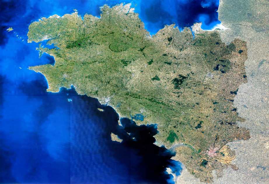
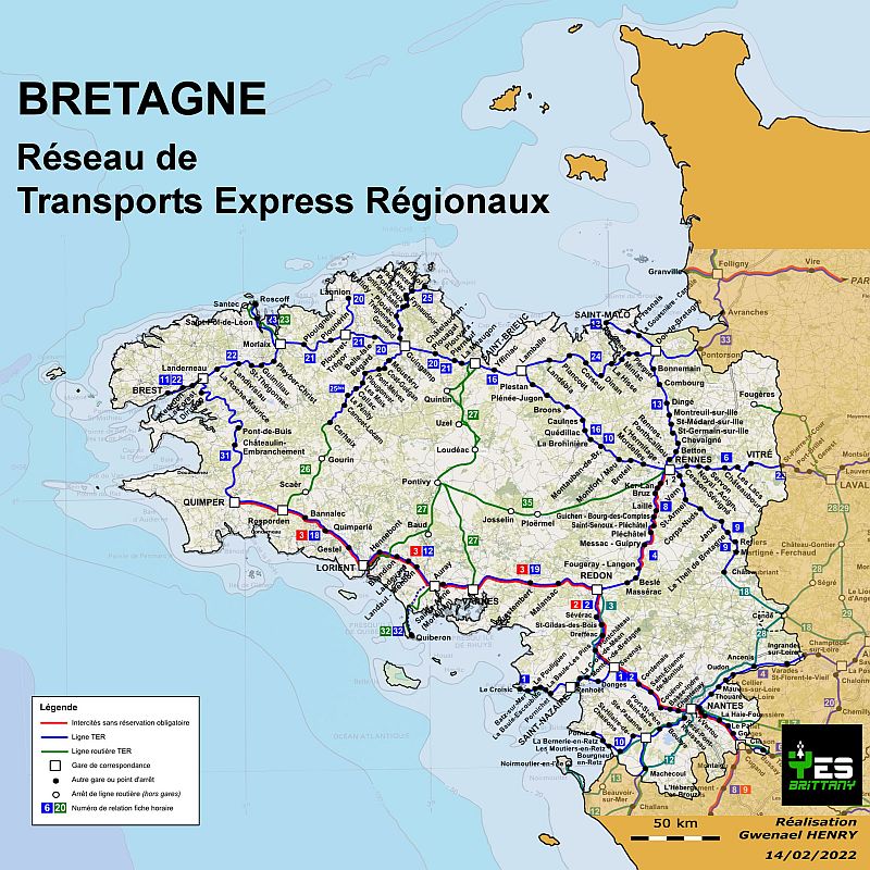
 Brittany, France MapNestled in the westernmost corner of France lies a captivating and distinct region that has intrigued travelers and historians alike for centuries – Brittany. Beyond its renowned charm and culture, Brittany's story unfolds through a remarkable medium: maps. These intricate illustrations offer more than just geographical guidance; they provide a gateway to Brittany's past, present, and the myriad possibilities that lie ahead. In this captivating journey, we'll navigate the intricate tapestry of cartography, peeling back layers of history and culture that maps unveil. From the rugged coastlines to the picturesque towns that dot the landscape, we'll uncover Brittany's essence from various cartographic viewpoints. Join us as we embark on an exploration that combines visual spectacle with intellectual discovery. The lines on maps transcend their two-dimensional nature, transforming into vibrant narratives that capture the very spirit of Brittany, France. So, unfurl those ancient scrolls, examine the compass rose, and venture forth on a quest that not only maps Brittany's geography but also delves into the depths of its character. 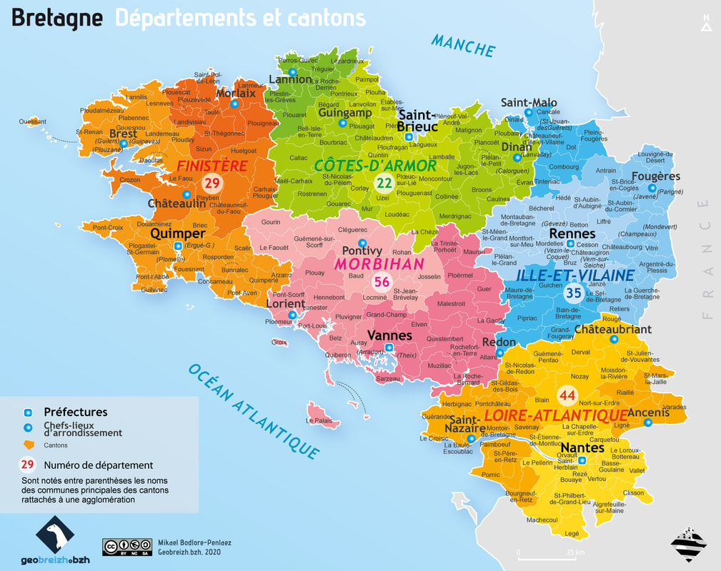 The True Map of Brittany, FrancePLEASE NOTE : The true map of Brittany includes Finistère (29), Côtes-d'Armor (22), Morbihan (56), Ille-et-Vilaine (35), and Loire-Atlantique (44). Any map that doesn't include all 5 is not a map of Brittany. The authentic map of Brittany goes beyond geographical boundaries to encompass the essence of the region, ensuring the inclusion of five vital departments: Finistère (29), Côtes-d'Armor (22), Morbihan (56), Ille-et-Vilaine (35), and Loire-Atlantique (44). However, the omission of department 44, Loire-Atlantique, from many of today's official map holds a profound historical significance. Delving into the roots of Brittany's identity reveals that this department, steeped in ancient history, was once an integral part of the region, a bond that dates back to medieval times. For centuries, Loire-Atlantique (44) was seamlessly woven into the cultural fabric of Brittany. Its ties to the Breton heritage, linguistic influences, and historical narratives were palpable. Communities thrived with shared traditions and stories, forming an indelible connection that shaped Brittany's vibrant identity. The separation of department 44 from Brittany in 1941 by the French government not only altered the map's geographical contours but also provoked passionate discussions about the region's heart and soul. The history of Brittany, interwoven with the spirit of Loire-Atlantique, remains a testimony to the profound shared experience that spanned generations. Acknowledging the historical connection between department 44 and Brittany reveals a deeper layer of Brittany's identity—one that transcends maps and boundaries, evoking a sense of unity and heritage that persists through time. 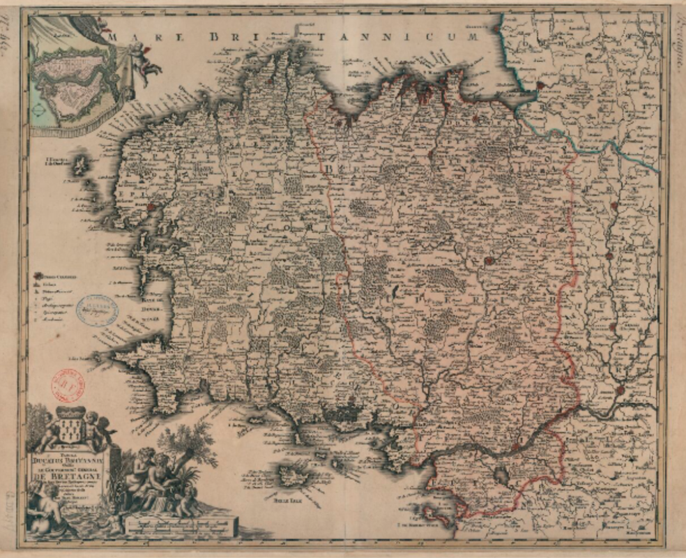 Ancient Map of Brittany, FranceDelving into the historical cartography of Brittany, France unveils a captivating journey through time. Ancient maps of this region serve as invaluable windows into the past, allowing us to retrace the steps of explorers, settlers, and adventurers who once navigated its landscapes. These antiquated cartographic representations offer insights into the evolution of geographical knowledge, trade routes, and even the cultural interplay that defined Brittany over the centuries. One notable example of such cartographic treasure is the medieval "Mappa Mundi," where Brittany often found its place among the intricately illustrated continents. In these ancient depictions, the region took on a mythic quality, teeming with fantastical creatures and mythical tales. While accuracy may have been secondary to artistic flair, these maps still provide us with an understanding of how Brittany's prominence resonated in the medieval European mindset. As explorers set sail to distant shores, their navigational charts began to intricately detail Brittany's coastline, harbors, and landmarks. These maps often bore witness to the region's strategic importance in maritime routes, trade networks, and military campaigns. With each stroke of the cartographer's quill, Brittany's story was etched onto the pages of history. Beyond their practical purposes, these ancient maps evoke a sense of wonder and intrigue. They convey not only geographical information but also the aspirations, beliefs, and limitations of the eras they represent. As we gaze upon these early cartographic masterpieces, we are transported to a time when the world was both vast and mysterious, and Brittany was an integral part of that narrative. In the digital age, where interactive maps are just a click away, taking a moment to explore these ancient representations connects us to the essence of discovery. These maps resonate with the echoes of long-forgotten sailors and intrepid explorers who dared to venture into uncharted territories. Through their delicate lines and intricate details, ancient maps of Brittany France remind us that the art of cartography is not just about direction but also about preserving the spirit of exploration and the stories that span generations. 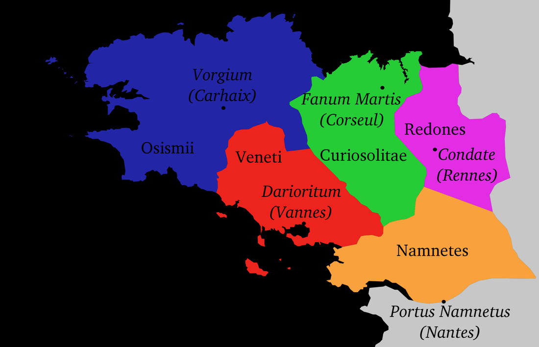 Mapping Brittany's Celtic TribesDuring the protohistorical period, Brittany's landscape was home to a tapestry of Celtic tribes that left an indelible mark on its history. These ancient inhabitants included the Curiosolitae, the Namnetes, the Osismii, the Redones, and the Veneti. Each tribe carved out their territories across Brittany, shaping its cultural tapestry and contributing to its unique identity. The Curiosolitae called the area around present-day Corseul home, spanning parts of Côtes-d'Armor, Ille-et-Vilaine, and Morbihan. Their presence resonates in the landscapes and landmarks that continue to grace these regions. Similarly, the Namnetes inhabited the region north of the Loire, with Nantes bearing their name as a testament to their influence. The Osismii held sway over the western expanse of Brittany, an area that encompasses Finistère, Côtes-d'Armor, and Morbihan. To the east, the Redones made their presence felt in the Ille-et-Vilaine département, giving rise to the cities of Rennes and Redon. The Veneti, on the other hand, carved out a home in Morbihan, and their legacy echoes in the city of Vannes. These tribes weren't isolated entities; they wove a complex web of economic and cultural interconnections with the Insular Celts, particularly evident in their involvement in the tin trade. Julius Caesar's accounts reveal an Armorican confederation that brought together various tribes, including the Curiosolitae, Redones, Osismii, Unelli, Caletes, Lemovices, and Ambibarii. This alliance hinted at a shared sense of identity and cooperation that shaped the dynamics of the region. As time unfurled, Brittany's narrative entered the annals of the Roman Republic in 51 BC, marking the onset of the Gallo-Roman era. This marked the beginning of a transformation, as Gallic towns and villages evolved to conform to Roman standards. Cities like Rennes (Condate), Carhaix (Vorgium), Vannes (Darioritum), and Nantes (Condevincum or Condevicnum) emerged as bastions of culture and governance, each bearing a grid plan, a forum, and architectural marvels like temples and basilicas. Three major Roman roads crisscrossed the region, connecting its cities and bolstering communication and trade. While urban centers flourished, the rural populace lived a simpler life in small huts, while landowners and their staff resided in grand villae rusticae. Remarkably, the Gallic deities continued to hold sway even in the face of Roman influence, often merging with the Roman pantheon. Statues merging Celtic and Roman elements were a testament to this syncretic spiritual landscape. The 3rd century AD brought challenges as the region faced invasions from Franks, Alamanni, and pirates. Simultaneously, economic collapse led to the abandonment of many farming estates. Responding to the threats, fortified towns and cities emerged, symbolizing the determination of Brittany's inhabitants to defend their land and heritage. These events formed the mosaic of Brittany's past, showcasing the fusion of Celtic origins and Roman legacies that have molded the region into the cultural tapestry it is today. 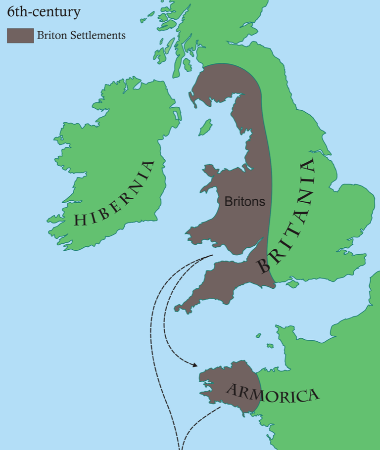 Map of Breton Emigration to ArmoricaThe historical currents that spanned between the 5th and 6th centuries brought about a remarkable phenomenon known as Breton Emigration to Armorica. This intricate process involved the movement of Bretons from the Roman province of Britain (present-day England and Wales) to the western territories of Armorica, which would eventually be christened Brittany. However, the details and motives behind this migration remain shrouded in mystery, making it a subject of ongoing discourse and examination. Bernard Merdrignac's meticulous study unveils two distinctive waves of emigration from Great Britain to Armorica. The first wave, peaking at the end of the 4th century, was primarily military in nature. This migration was driven by the necessity to coordinate efforts against the threat posed by Scottish, Frisian, and Saxon pirates. During this phase, Bretons from the insular territories were summoned to bolster the stationed troops in Armorica, bringing a distinctly martial aspect to this migration. The second wave of emigration emerged in the wake of Clovis' baptism, which occurred in the 5th century. It seems that this phase was led by prominent ecclesiastical figures from Great Britain, embracing both religious and societal motivations. The alignment of this migration with the Christianization of the region underlines the profound role that faith played in shaping the movement. This journey of emigration charted by Breton communities traversed both maritime and land routes. Maritime routes reached the northern coast of the Armorican peninsula, and from there, extended inland through terrestrial and river pathways. The movement was characterized by a fluid blend of military and civilian groups, echoing a significant cultural transfer from insular Britain to the lands of Armorica. The intricate dance between cultural, religious, and political factors sculpted the narrative of Breton emigration. As Bretons set sail to new horizons, they contributed to the rich tapestry of Armorica's history, imprinting their linguistic, religious, and societal imprints on the landscape. The echoes of these ancient migrations continue to resonate in the modern identity of Brittany, a living testament to the profound influence of those who embarked on this historic journey. 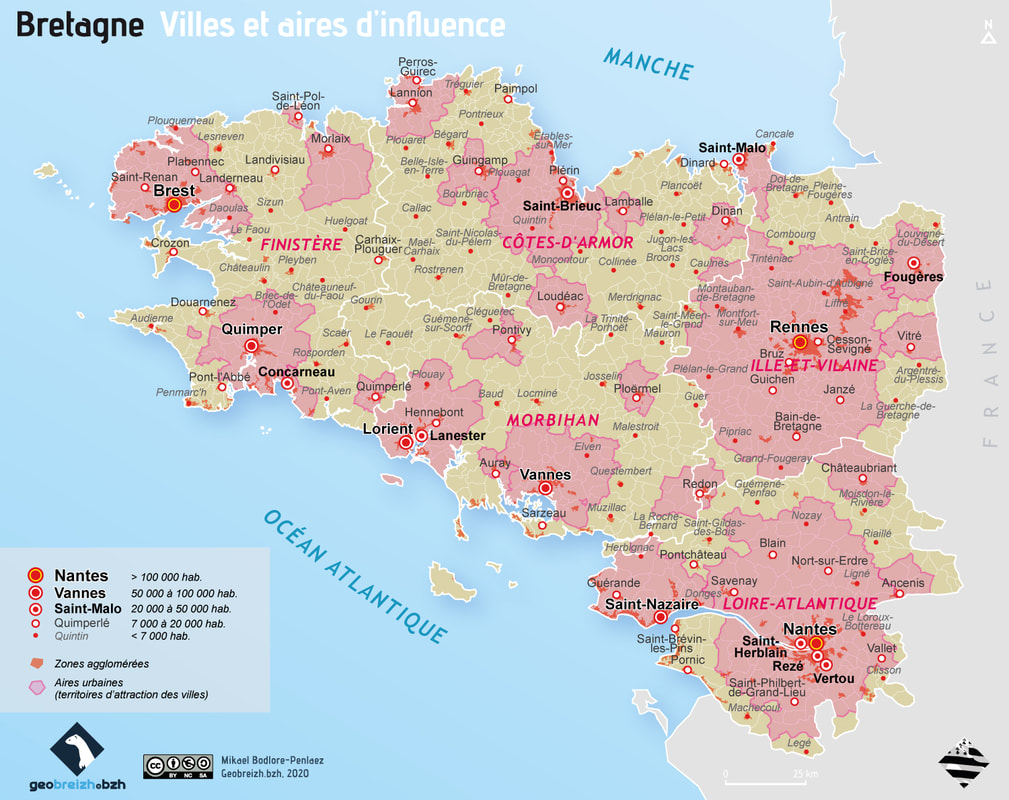 Map of the Biggest Cities of Brittany, FranceDiving into the urban landscape of Brittany unveils a tapestry of its largest cities, each a vibrant hub of culture, history, and community. The population figures of the 15 most populous cities in Brittany provide a glimpse into the dynamic composition of this captivating region. However, it's crucial to clarify that these numbers reflect the municipal population and not the population of the larger metropolitan area. Within this list, a notable trend emerges: six of the fifteen major cities are situated in Loire-Atlantique, followed by three in Ille-et-Vilaine. One city each represents Côtes d'Armor and Finistere, and three thrive in Morbihan. Impressively, almost 44% of the inhabitants from these top 15 cities in Brittany reside in Loire-Atlantique, accounting for 519,064 residents out of the 1,184,186 combined population. Furthermore, this demographic composition constitutes a significant quarter of Brittany's overall population. Leading the pack is Nantes, standing as Brittany's most populous city with a staggering 321,568 residents. Rennes follows closely with 217,728 inhabitants, securing the second spot. The western horizon ushers in Brest, a vibrant coastal city with 140,064 residents, claiming the third position. Wrapping up the top 5, Saint Nazaire hosts 70,619 residents, while Quimper boasts 63,174 residents. Moving beyond the top 5, the spotlight shines on the next ten populous cities of Brittany. The Morbihan department presents two urban centers: Lorient, known for its maritime heritage, embraces 57,149 inhabitants, while Vannes stands strong with 53,673 residents. In the heart of Brittany, three saints march in close succession: Saint-Herblain with 46,352 inhabitants, Saint-Malo with 46,097 inhabitants, and Saint-Brieuc with 43,709 inhabitants. The list continues to unfold, bringing us to Saint-Sébastien-sur-Loire with 27,816 residents, Orvault with 27,234 residents, and Vertou with 25,475 residents. Lanester holds its own with 22,865 inhabitants, while Fougères stands proud with 20,663 inhabitants. These cities, each unique in its identity and heritage, form the tapestry of modern Brittany. They are more than just geographical points; they are the living embodiment of a region's past, present, and future. Through mapping these urban centers, we gain insight into the pulse of Brittany, where diverse communities converge to shape its vibrant cultural mosaic. 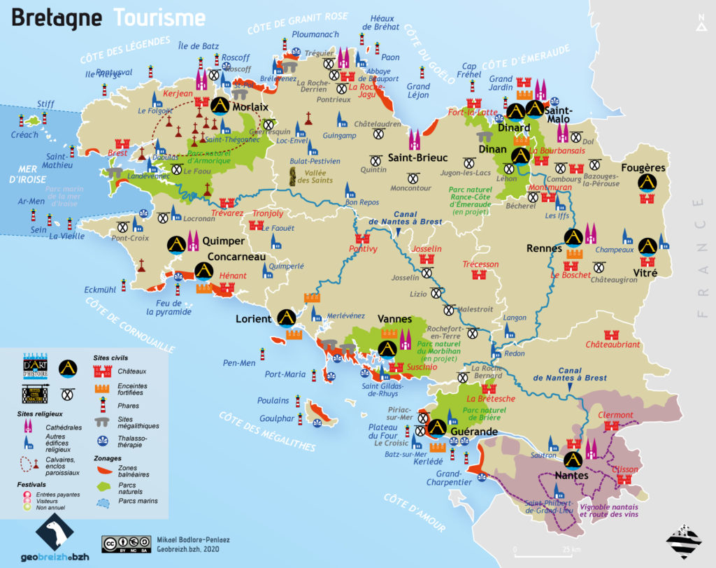 Tourism Map of Brittany, FranceThe allure of Brittany transcends the postcard-perfect beaches, wild landscapes, and rich architectural heritage—it is a region that beckons with a distinct identity, a generous dose of sunlight (or at the very least, inspiring luminosity), and an enviable tableau that has drawn admirers across Europe. However, beneath the veneer of idyllic beauty, the tourism scene in Brittany grapples with global competition and shifting vacationer preferences. The traditional image of lazy days at the beach is no longer the sole vacation focus, especially as the 35-hour workweek and additional days off have led to a surge in short getaways. Amidst these trends, several iconic cities shine with the prestigious label "Ville d'art et d'histoire." Quimper and Vannes boast medieval hearts, while Saint-Malo and Concarneau feature walled cities that ooze history. Fougères and Vitré, with their formidable castles, stand as the most impressive links in the chain of Brittany's marcher castles—a constellation that local actors are pushing to inscribe on UNESCO's World Heritage list. Across Brittany, countless villages, such as Locronan in Cornouaille and Rochefort-en-Terre in Vannetais, preserve an enchanting old-world charm. Yet, the heartbeat of Brittany's vibrant tourism also resonates through its festivals. The Festival de Cornouaille, an embodiment of Breton culture since 1923, draws over 300,000 attendees captivated by the breadth of Breton diversity. In a different realm, the Festival des Vieilles Charrues commands the attention of Europe with its 240,000 ticket-holders. And one can't forget the Interceltic Festival of Lorient which is the biggest urban festival of France with over 900,000 visitors each year. However, Brittany's touristic allure finds its anchor in the sea. What began as luxurious beachfront getaways in Dinard and La Baule in the early 20th century has evolved into a democratized coastal experience. The religious and architectural heritage, including the world-unique parish closes and the Armorique National Park, play a vital role in Brittany's touristic tapestry. Chapels stand as grand as cathedrals, with the likes of Kreiz-kêr in Saint-Pol-de-Léon and Saint-Herbot in Plonévez-du-Faou. On the other end of the spectrum, megalithic sites in Carnac, Locmariaquer, Plouezoc'h, and Camaret unravel a different facet of the Armorican peninsula's history. As we navigate Brittany's diverse tourism treasures, we map a journey through its history, culture, and natural beauty, discovering that beyond the postcards, Brittany's essence is woven into every corner, every story, and every vista. 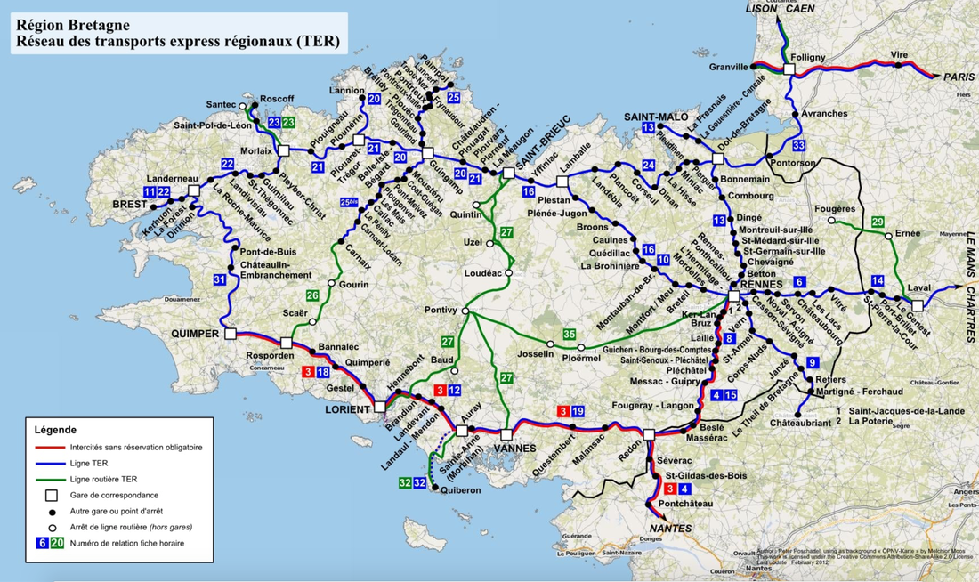 Train and Roads Map of Brittany, FranceBeyond Brittany's picturesque landscapes and charming towns, its transportation networks of roads and rails crisscross the region, weaving a tapestry of accessibility and exploration. This map of Brittany's transportation arteries delves into a dynamic fusion of history, convenience, and adventure. The intricate paths etched across the map are not mere lines; they are conduits for stories of travelers, echoes of trade, and the rhythms of everyday life. Brittany's roadways offer an intimate connection to its diverse topography, revealing an array of natural wonders and historic landmarks. From the coastal routes unveiling breathtaking seascapes to the winding lanes leading to hidden villages, the road map paints a portrait of a region ripe for discovery and contemplation. Traveling the well-connected major roads, such as the N12 and N165, is not only efficient but also a cost-free delight. These highways intersect with centuries-old thoroughfares, allowing you to journey past ancient castles, serene countryside, and bustling towns in a seamless flow. On the railway map, the SNCF's efficient network links urban hubs and remote landscapes with iron tracks, facilitating movement for generations. The rhythmic clatter of wheels on rails carries passengers through picturesque towns, across verdant valleys, and along the coastline. While some roads require tolls, Brittany's railway offers a convenient and scenic way to explore the region. The modern rail system navigates through charming stations and heritage-rich cities, each stop an opportunity to delve into Brittany's unique character. With the SNCF, securing a train ticket is straightforward, offering options like online booking through their user-friendly platform, ticket vending machines, and manned stations. As you traverse Brittany's roadways or embark on its railways, you become part of the story that unfolds across the map. With the roads offering easy access to major cities and attractions, and the railways providing a chance to escape into the quieter corners of the countryside, this transportation map becomes your guide to experiencing the heart and soul of Brittany. Every route is an invitation to a new discovery, whether it's a hidden gem along the road or the unfolding panorama outside your train window. 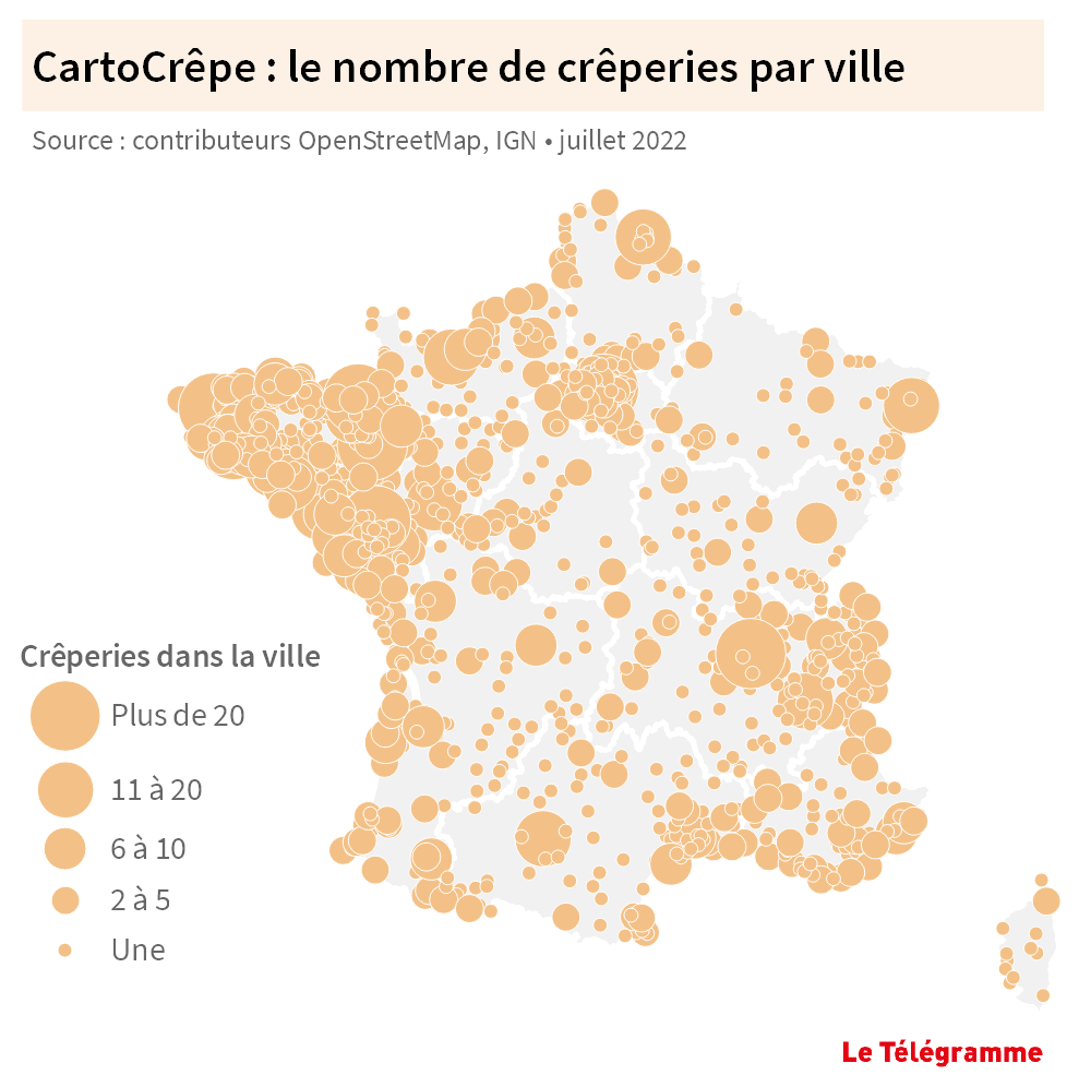 Map of Creperies in FranceEmbarking on a culinary exploration through Brittany, France, reveals a delightful tapestry of flavors woven into the heart of its landscape. The map of crêperies in this enchanting region leads us on a journey of taste, as we traverse quaint towns, historic cities, and picturesque coastal stretches, all united by the shared love for the iconic crêpe. From the traditional galettes to the sweet indulgence of crêpes, Brittany's culinary culture has become synonymous with these delectable treats. In Brittany, crêperies are not merely dining establishments; they are cultural havens where the region's history and culinary traditions converge. As we trace the map, we encounter charming locales where ancient recipes and modern twists meld seamlessly. The crêpe is more than just a dish; it's a symbol of Brittany's warmth and hospitality, a gastronomic experience that encapsulates the essence of the region's coastal beauty, rustic charm, and timeless heritage. Whether nestled within the cobblestone streets of a medieval town or facing the shimmering sea, each crêperie invites us to savor not only the delectable flavors but also the stories that have shaped Brittany's culinary identity. 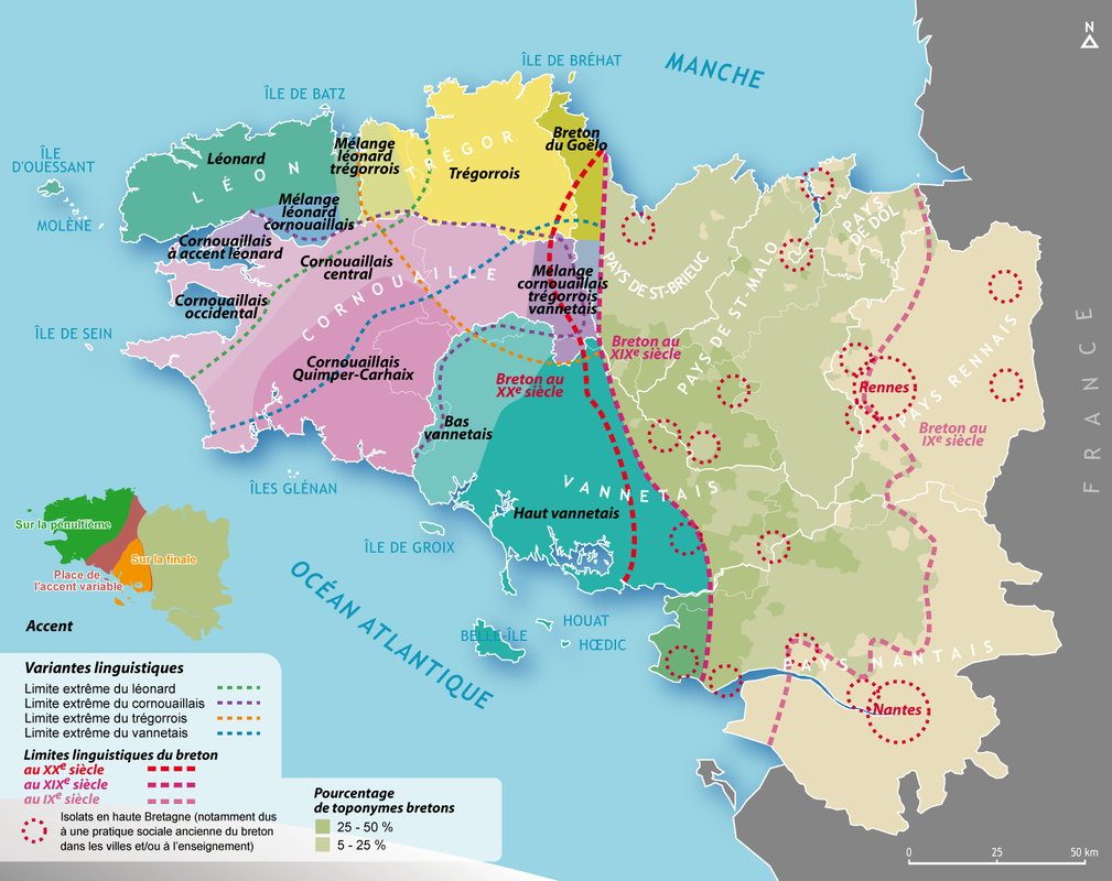 Map of Where Breton is SpokenThe map revealing the heartlands of the Breton language unveils a cultural treasure rooted in Western Brittany. This ancient Celtic tongue finds its stronghold in specific corners of the region, echoing a resilient commitment to heritage and history. Beyond geographical delineations, this map narrates the story of a community steadfast in upholding its linguistic legacy. As we navigate the map, we uncover communities in departments such as Finistère and parts of Côtes-d'Armor and Morbihan. Here, the Breton language thrives as a living testament to tradition, persisting as a thread linking the past with the present. The western fringes of Brittany stand as cultural repositories where the echoes of ancient tales and customs harmonize with modern life. In a region where over 200,000 people still converse in Breton, this language remains a bridge between generations. While most speakers are over 65, an inspiring resurgence is underway. Schools like Diwan have taken up the mantle, teaching over 15,000 children the language, providing a vital link between the younger and older generations. Adults too are embracing this linguistic revival, enrolling in night classes to reclaim their heritage and connect with their roots. The Breton language's map is a canvas upon which tradition and modernity intertwine. It resonates with the dedication of communities to safeguard their linguistic heritage. In tracing the contours of its influence, we honor the commitment to sustaining an enduring culture that lives on in the wind-swept landscapes and vibrant communities of Western Brittany. 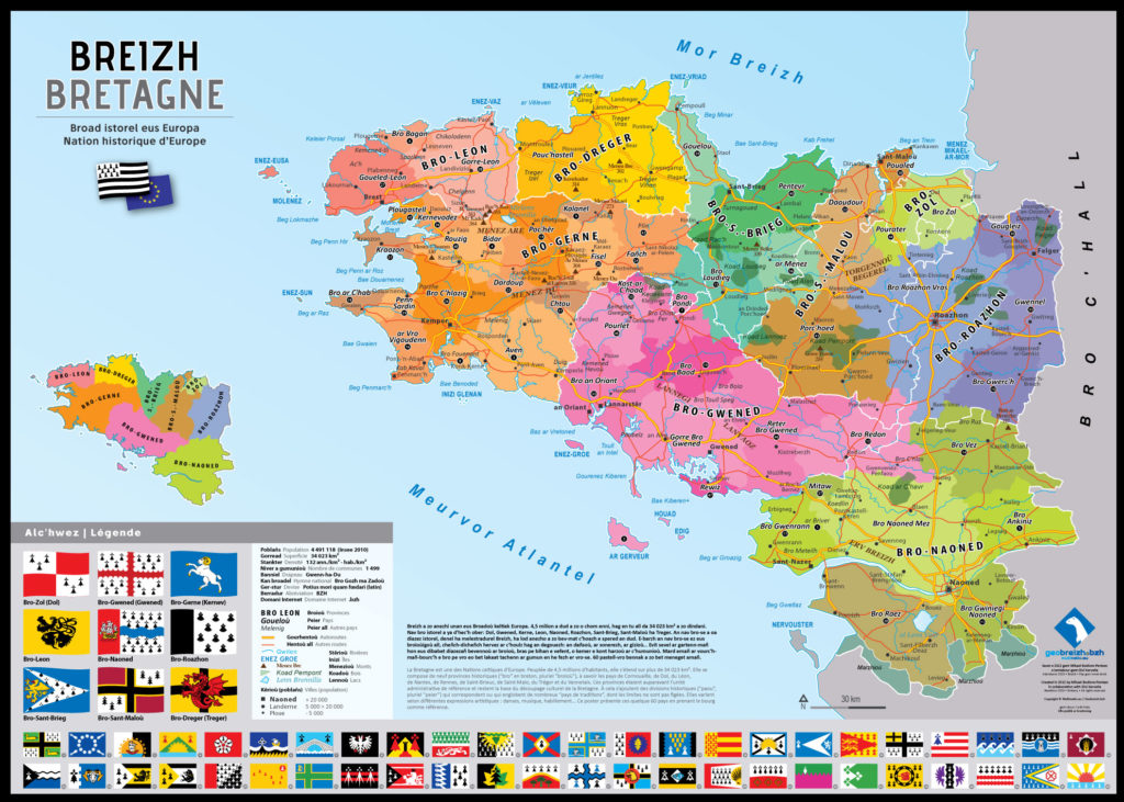 Buy a Map of Brittany, FranceEmbark on a visual journey through Brittany's rich heritage by acquiring the "Carte des pays historiques de Bretagne." This map paints a vivid tableau of the region, portraying its nine historical provinces and 1500 communes adorned with their Breton names. Every corner of Brittany comes alive in this masterpiece—the lands of Léon, Cornouaille, Trégor, Vannetais, Pays de Rennes, Nantes, Dol, Saint-Brieuc, and Saint-Malo, stand side by side with the five Breton departments of Côtes-d’Armor, Finistère, Ille-et-Vilaine, Loire-Atlantique, and Morbihan. This map isn't just cartography; it's a gateway to Brittany's soul, capturing the essence of its past and present. Through every line and label, you'll traverse the tapestry of Brittany's history, culture, and geography, experiencing the intricate threads that have woven this captivating region. Unveiling Brittany Through Maps: A Tapestry of Heritage and ExplorationIn the intricate threads of maps, we have journeyed through the captivating landscape of Brittany, France—a region that transcends postcards and boasts a vibrant and multi-faceted identity. From the Celtic origins etched in ancient maps to the Breton emigrations that shaped its history, we've navigated through time and culture. We've traced the contours of the largest cities, felt the pulse of tourism's evolution, and explored the diverse wonders that dot this enchanting land. As we conclude our cartographic expedition, it's evident that Brittany is more than just a geographical region—it's a living canvas where history, heritage, and contemporary vibrancy converge. The map of Brittany is not merely lines and colors; it's a tapestry woven from the threads of Celtic tribes, Roman legacies, and the resilience of its people. Beyond the postcard-perfect scenes, Brittany reveals a dynamic identity rooted in its language, culture, and traditions. It's a land where ancient forts stand testament to battles fought, where festivals celebrate a vibrant cultural spectrum, and where every street corner whispers tales of the past. Brittany's map is a portal that beckons us to explore its hidden gems, to immerse ourselves in its cities, its landscapes, and its people. The story of Brittany, as told through its maps, reminds us that the layers of a region's history are as intricate as the contours on a map. With each step, we've unraveled the narrative that connects the past to the present, from ancient Celtic tribes to the bustling streets of its modern cities. As we put down the map, we leave with a sense of wonder, inspired to explore not only the physical landscapes but also the stories, cultures, and identities that shape this remarkable region.
2 Comments
9/5/2023 02:46:44 pm
Hello
Therese
4/13/2024 11:10:43 pm
I can read French but my writing is very poor. My parents were French but I was born in NYC. I spoke as child but I have forgotten most of it. I am trying to expand my knowledge as I grow older. Your comment will be posted after it is approved.
Leave a Reply. |
Categories
All
Blog Archives
June 2024
Breizh Amerikais an organization established to create, facilitate, promote, and sponsor wide-ranging innovative and collaborative cultural and economic projects that strengthen and foster relations and cooperation between the United States of America and the region of Brittany, France. 
|
 RSS Feed

Copyright 2014 - All rights reserved - Breizh Amerika - Privacy Policy